Compass Surveying
In chain surveying the network of control points is established with the help of linear measurements.But in case of compass surveying each control point is established with the help of both linear and angular measurements and this process is termed as traversing.
Basic difference between chain and compass surveying are:
| Chain surveying | Compass surveying |
| It requires only linear measurements. Here the framework consists of a network of triangles. Check lines are required in chain surveying. Used when the area to be surveyed is small, ground is flat and accuracy required is low. | It requires both linear and angular measurements. Here the framework consists of connected lines forming an open or close polygon. Here accuracy is checked by method of adjustment. It is suitable for large areas where accuracy required is more. |
Note: Here framework consist of number of connected lines, forming open or closed polygon according to which it is further classified as
Classification of Traverse
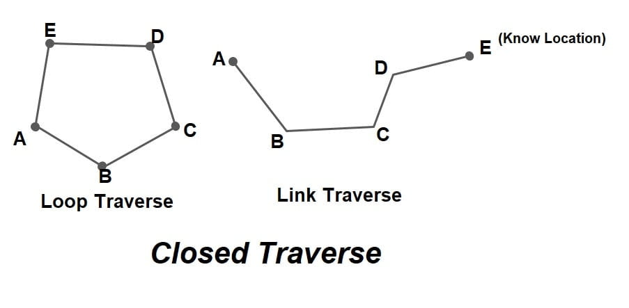
A). Closed Traverse
- A closed traverse starts from a station and closes either on the same station or another station whose location is already known.
- If a traverse starts and ends at the same point whose location is known this type of closed traverse is termed as loop traverse.
- If a traverse starts and ends at different points of known location, this type of closed traverse is termed as link traverse.
- In cased closed traverse, it is easy to detect the error and adjust or balance it.
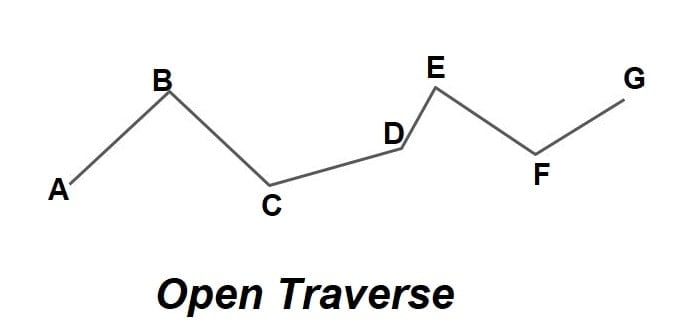
B). Open Traverse
- An open traverse is that where the start station is known or established, but the station at which the traverse is complete/closes is not known or established.
- It is used for the survey of roads, railways, canals, tunnels etc.
- An open traverse cannot be properly checked and adjusted or balanced hence it is avoided.
Note. Traversing can be done by any of following methods.
- Compass traverse
- Plane table traverse
- Stadia traverse
- Theodolite traverse.
Compass traverse
In compass traverse, A magnetic compass is used for measurement of angles and chain/tape is used for linear measurement.
Meridian
The direction of a line is defined by the horizontal angle which the line makes with a reference line. The fixed line of reference is called a meridian. There are 4 types of meridians used in surveying.
- True meridian
- Magnetic meridian
- Grid meridian
- Arbitrary meridian.
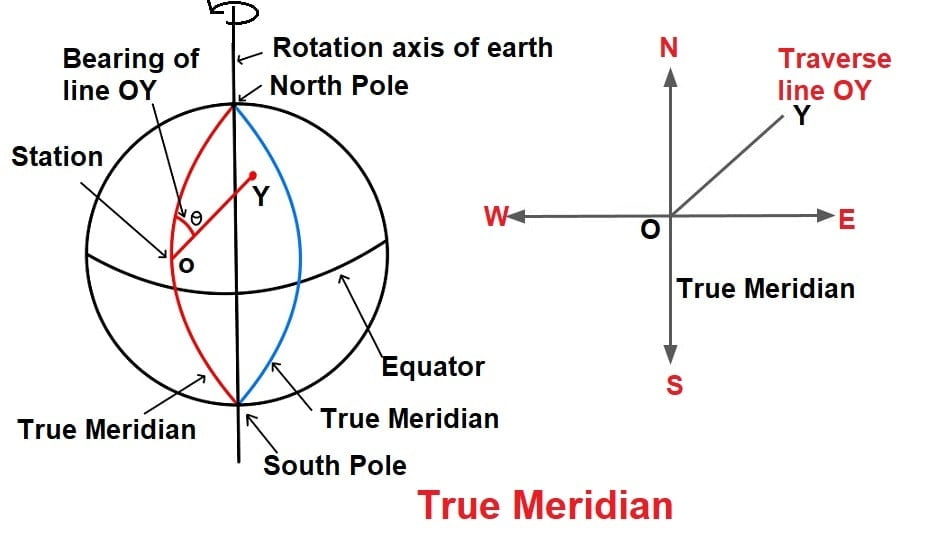
True Meridian
- The line or plane passing through the geographic north pole & geographic south pole along the earth is called the true meridian.
- It represents the true north-south direction at the place.
- True meridian at a point can be determined by astronomical observations.
- True Meridian on earth surfaces are not parallel, but converge at the pole. For small areas, they are assumed to be parallel to each other.
- True meridian at a point is always fixed.
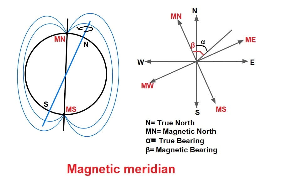
Magnetic meridian
- The line or plane passing through the magnetic north pole & magnetic south pole along the magnetic flux line is called the magnetic meridian.
- Magnetic poles are not fixed hence magnetic meridian is also not fixed and change with time.
NOTE
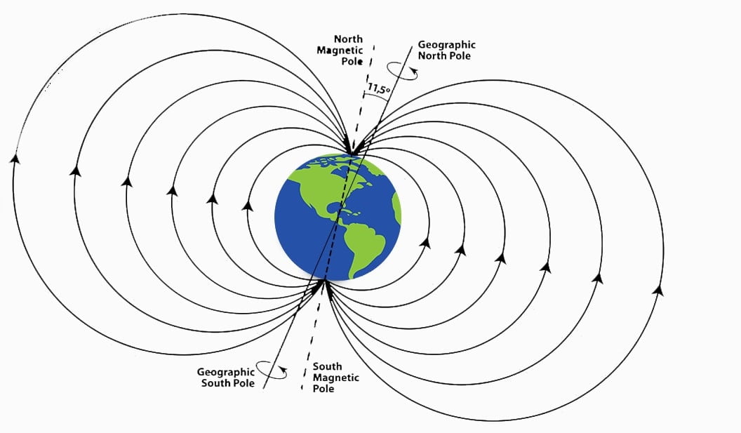
The geographic north (true north) and geographic south (true south) poles are the spots on the earth’s surface where the rotation axis intersects. The geographic north and south poles are fixed. The north pole is the top of the earth. And the south pole is the bottom of the earth. It determined by astronomical observations.
Where magnetic compass points to the earth’s that is magnetic poles, which differ from its geographic poles.Where the magnetic compass indicates the north of earth that is magnetic north poles. And Where the magnetic compass indicates the south of earth that is magnetic south poles. Magnetic poles are not fixed.
Grid Meridian
- For survey of a country, the true meridian passing through the central place is sometimes taken as a reference meridian for the whole country. Such a reference meridian is known as grid meridian. The meridians of all other places in that state are assumed to be parallel to the grid meridian.
- A line parallel to the grid meridian and passing through the point indicates the directions of the grid north and south. Like this rectangular grids are plotted on the map.
Arbitrary Meridian
- Arbitrary meridian is the meridian which is taken in any convenient, arbitrary direction. Any reference line may be taken as arbitrary meridian. But usually it is taken in the direction from a traverse station to a well-defined, permanent point such as a church spire, the chimney, etc. Sometimes, even the first traverse line is also taken as an arbitrary meridian.
- The arbitrary meridian is used for determine the relative directions of various lines in a small traverse.
Bearing
Horizontal angle measure for a line with respect to reference line (meridian) is called bearing. Depending upon the meridian, there are 4 type of bearing.
- True Bearing
- Magnetic Bearing
- Grid Bearing
- Arbitrary Bearing
Types of bearing
True Bearing
- Bearing measured with respect to true meridian is called true bearing.
- The true bearing of a line is also called as Azimuth.
- In plane surveying, the true bearing is measured from the true north.
- The true bearing of a line can be determined by astronomical observations.
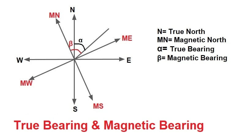
Magnetic Bearing
- Bearing measured with respect to magnetic meridian is called magnetic bearing.
- As the magnetic meridian changes slowly with time, the magnetic bearing of a line also changes with time. Hence the magnetic bearings are used for small, less important surveys.
- The magnetic bearings are determined with the help of a prismatic compass as a whole circle bearing and with a surveyor’s compass as a quadrantal bearing.
Grid Bearing
- Bearing measured with respect to grid meridian is called grid bearing.
Arbitrary Bearing
- Bearing measured with respect to arbitrary meridian is called arbitrary bearing.
Designation of Bearing or Representation of Bearing
The bearing of a line is designated in the following systems.
- Whole Circle Bearing System
- Quadrantal Bearing System
Whole Circle Bearing System
- The whole circle bearing of the line is the horizontal angle between the line and the north end of the reference meridian in the clockwise direction.
- The whole circle bearing of a line may vary from 0 to 360°.
- The whole circle bearing is measured with a prismatic compass.
Quadrantal Bearing System
- The quadrantal bearing of a line is the actual angle which the line makes with the Meridian. Thus quadrantal bearing is measured from the north point or the south point in the clockwise or anticlockwise direction. whichever is closer therefore the quadrantal bearing of a line cannot be greater than 90°.
- The letters N, E, S and W are used to represent north, east, south and west respectively. While writing the quadrantal bearing of a line following rules are used.
- First the letter N or S.
- Then the angle of the bearing.
- Lastly the letter E or W.
- The quadrantal bearing of a line is measured with a surveyor’s compass.
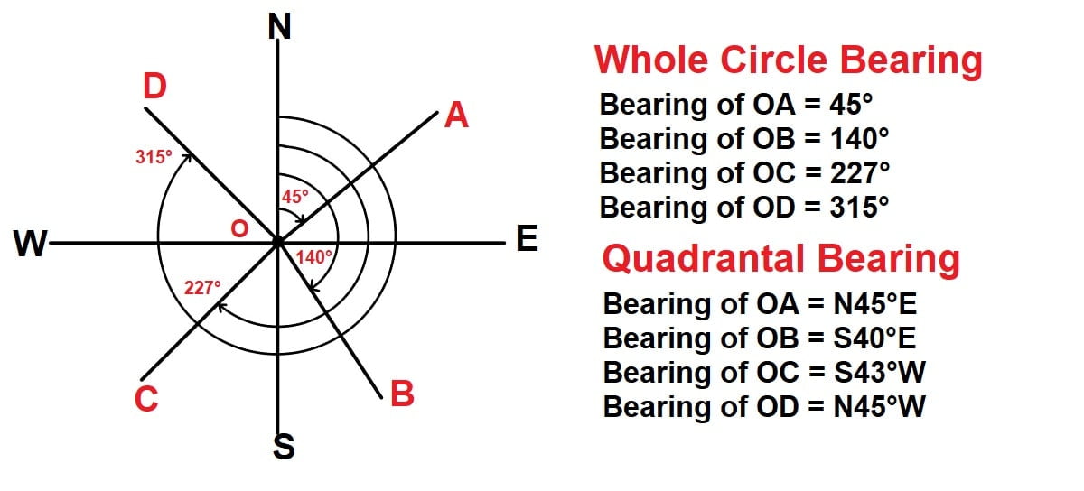
NOTE: In the quadrantal bearing system the angle measured can be either clockwise or anti-clockwise.
nice well prepared and useful content.