In fundamentals of surveying (part-1), we details analysis about surveying, classification of survey, principal of surveying, instruments used for various types of measurement.Etc
SURVEYING
Surveying is the process of determining the relative position of points on, above and below the surface of earth by means of direct or indirect measurement of “Distance”, “Direction”, and “Elevation”.
It may also be termed as the process of establishing the point by predetermined angular or linear measurement.
Classification of survey based on the curvature of the earth surface.
1.Plane Survey
Survey in which the effect of earth curvature is not considered is called plane surveying.It is suitable for a small area less than 195.5 km².All the line and triangle formed during survey in this case will be considered as plane line & plane triangles.Here the level line is considered to be a straight line and pump lines are considered to parallel to each other at different points.
2.Geodetic Survey
Survey in which the effects of earth curvature are considered is called geodetic surveying.It is suitable for a large area greater than 195.5 km² and a high degree of precision is required. Here all lines lying on the surface are curved lines and triangles are spherical triangles. Here the level line is curved and pump lines are interested to each other at different points.
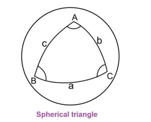
Spherical triangle is that triangle which is formed upon the surface of the sphere by intersection of three arcs of great circles and the angles formed by the arcs at the vertices of the triangle are called the spherical angles of the triangles.
Properties of a spherical triangle
- Any angle is less than two right angle or π or 180. (A or B or C < 180)
- The sum of the three angles is less than six right angles or 3π or 540° and greater than two right angle or π or 180°. [180° < (A + B + C) < 540°]
- The sum of any two sides is greater than the third (a+b>c, a+c>b, b+c> a).
Note
For any triangle with area 195.5 sq.km, the sum of the interior angle could be just 1” (1 second) is extra in geodetic survey.
For any line of length 12 km, it is just 1 cm extra in geodetic survey.
Classification of survey based on Place
1.Land Survey
Here surveying is done for the feature on land. It is further classified into the following type.
(i).Topographical Survey
This type of survey is conducted to located natural and artificial features present on the earth surface. Artificial features are building, mountains etc while natural features means hills, rivers etc.
(ii).Cadastral Survey
To know about properties line & calculation of land area.
(iii).City Survey
To define different services in a city like construction of street, water pipeline, Sewers, LPG line etc.
2.Hydrographical Survey
This type of survey deals with water bodies like streams, lakes etc.It is also called bathymetric surveying which is done to identify physical features present underwater.
3.Astronomical Survey
To know about the position of the star, moon, and sun.
Classification of survey based on Purpose
1.Engineering Survey
This is done to find sufficient data to be used for engineering design work like roads, reservoirs, sewers, etc
2.Military Survey
It is used for determining points of strategic information.
3.Archaeological Survey
In the survey gathers information about the ancient mountain, towns, village, kingdom, past civilizations, temples etc. it gives an idea about the past history, culture etc of the civilization that existed in the past.
4.Mine Survey
It is being carried out for exploration of new mines.
5.Geological Survey
This survey helps in determining the type of foundation, soil treatment required ets.
Classification of survey based on Instrument
1.Chain Survey
It is the simplest type of survey in which only linear measurements are taken either with chain or tape.
2.Compass Survey
In this type of surveying horizontal angles are measured with the help of magnetic compass, in addition to this linear measurement is taken with chain or tape.
Although magnetic compass is not precise in measuring angle hence this survey is not very accurate, however it is more accurate than chain surveying.
3.Levelling
In this type of survey, leveling instrument is used to determine the relative elevation (level) of various points in the vertical plane.
4.Plane table Surveying
In this survey, a map or plan is prepared in filled by observing the terrain after determining the direction of various lines and measuring the linear distance with chain/tape.
The accuracy of the survey is low, but in this case measurement and plotting are done together.
5.Theodolite Survey
In this type of survey theodolite is used for measurement of horizontal and vertical angle.
Its accuracy is comparatively more than compass survey.
It is further classified as
6.Tacheometric Survey
In this type of survey, a special type of theodolite called Tacheometer is used, which is filled with cross hairs in addition to central horizontal hair.
In this horizontal angle, horizontal distance and vertical distance are measured with a tacheometer.
It gives better results than theodolite survey in rough terrain.
7. Photogrammetric Survey
Photogrammetry is the process of taking measurements with the help of photographs.
It is generally used for topographic mapping of large areas.
It is used for areas which are difficult to access.
Photograph are prepared to be taken from ground but it is not possible aerial photography used.
8. EDM (Electronic Distance Measurement) Survey
In this type of survey linear measurement is done with the help of EDM.
Here also control from the triangle, hence termed as triangulation survey.
Triangulation survey in which the length of all sides of a triangle is measured is termed as “Trilateration”.
Principal of surveying
The fundamental principles of surveying are as follows
1.Working From Whole To Part
Whether a place of geodetic surveying is done, work is to be carried out from whole to part.
In this we establish the first system of control points with a degree of accuracy.
Minor control points are then established by less precise methods.
By doing so, accumulation of errors is avoided and minor errors are localized .
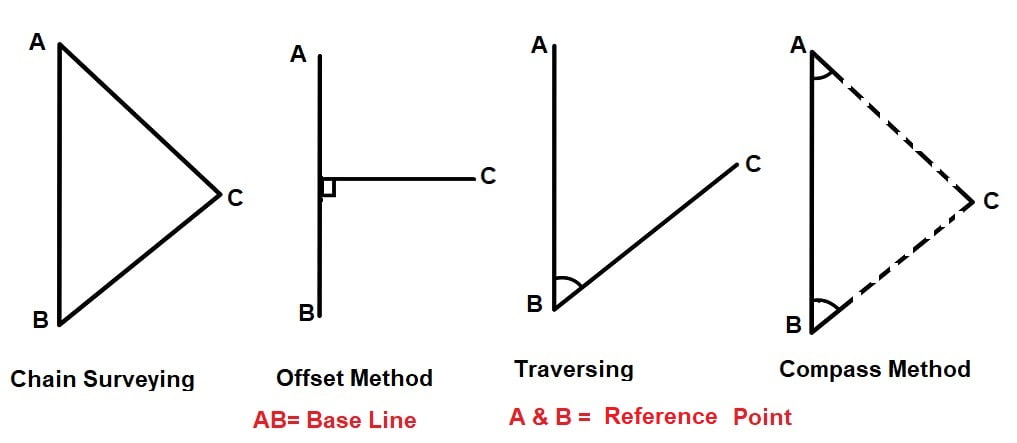
2.Location of a Point by With Respect to Reference Point
The relative positions of the points to be surveyed should be located by measurement from at least two points of reference, the position of which is already fixed.
Instruments Used for Various Types of Measurement
(a) For horizontal distance measurement: Tape, chain, tacheometer, EDM etc.
(b) For horizontal angle measurement: Magnetic compass, theodolites, total station, sextant etc.
(c) For vertical distance measurement: Tacheometer, levelling instruments like dumpy level etc.
(d) For vertical angle measurement: Sextant, clinometer, theodolite etc.