Introduction Of Transportation
The process of conveyance from one point to another is termed transportation.
Transportation has the following effect over the social-economic aspect of life:
- It helps in the progress and advancement of community.
- Efficient transportation is essential for the economic property and development of the country.
- It helps in moments of emergency for defense of the country and to maintain better law and order.
Different Modes of Transportation
Transportation can be achieved by any of the following mediums:
- Land.
- Water.
- Air.
- Conveyor belts
- Rope-way.
- Elevator.
- Cable card.
- Pipeline.
- Hyperloop.
The following four major modes of transportation are used:
- Railways
- Waterways
- Airways
- Roadways
Railways Transportation
- It is the moment of multiple wagon or a train of wagon with steel wheel over two parallel steel rail that offer come actively lesser resistance.
- Hence, the cost of transportation by this method is approximately one sixth (1/6) of that by road transportation, but it comparatively less flexible.
- Railway are considered as arteries of entries transportation system.
Water Transportation
- It offer minimum resistance to traction, hence each cheapest method amongst all.
- But the time required in this case comparitively more.
- It is suitable for transportation of bulk of relatively low value.
Air Transportation
- It is the fastest method among all transportation, but the cost involved in this age also very high.
- It is suitable for transportation of high value goods on long haul.
- This method is affected by weather condition like storm and fog.
Road Transportation
- It is most flexible mode of transportation amongst the all.
- But it consume petroleum product at high rate and rate of emission of pollutants in this case is also maximum.
- Major Road transportation is achieved by highway and Expressway.
Note:
Time of Travel: Airways<Roadways<Railways<Waterways
Cost of Travel: Airways>Roadways>Railways>Waterways
The major roads of transportation are achieved by highways & expressways.
Highway
A special type of Rood design to allow the high speed of vehicles it is generally Constructed over embankment due to the following advantages-
- Better drainage facilities.
- Safety in flood time.
- No lateral entry of public/animals.
Example- National highway, State highway.
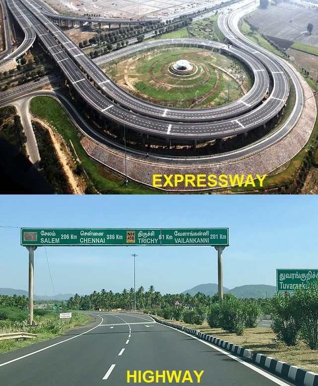
Express highway
A special type of highway express highway which is designed as a direct connectivity between two places. Express highways organized the traffic in a generalized way.
Example- Mumbai-Pune Expressway, Noida-Agara Expressway.
Characteristics of Road Transport
- Roads can accommodate various types of vehicles at a time, like passenger cars, trucks, pedal cycles, and animal-drawn vehicles.
- Road transport requires a relatively low capital investment for the government.
- Road transport offers complete freedom to road users to transfer the vehicle from one lane to another and from one road to another according to their needs and convenience.
- In particular, for short-distance travel, road transport saves time.
- Road transport is the only means of transport that offers itself to the whole community alike.
Importance of Roads in India
- Road development in India has contributed greatly to the increment in agricultural, commercial, and industrial sectors. It is essential to provide road links between the villages and market centers.
- Overall economic progress can be achieved, only if reasonably adequate transport facilities are made available between the villages and commercial centers.
- Road development also generates considerable employment potential.
- Revenue from road transport in India has been much higher than the investment made on road development plans.
Development of Road
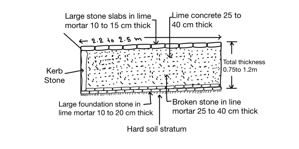
1. Roman Road
Firstly Roman started construction of roads in large scale in 312 BC of length over 580 km.
The main features of Roman roads are:
- They were built straight regardless of gradients.
- Total thickness of the construction was as high as 0.75 m to 1.2 m.
- They were built after the soft soil was removed and a hard stratum was reached.
- The wearing course consisted of dressed large stone blocks set in lime mortar.
Drawback
- No cross slope is provided.
- No drainage system.
- Large foundation stones were provided at bottom.
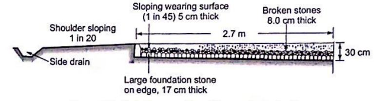
2. Tesaguet Construction
Pierre Tresaguet developed an improved method of construction in France during 1764 A.D.
The main features of Tresaguet construction are:
- The thickness of the road was the order of 30 cm.
- Consideration was given to subgrade moisture conditions and drainage of surface water.
- The sub-grade was prepared and a large layer of foundation stone was laid on the edges which act as Kerb stone.
- The top wearing course was made up of a smaller slope having a cross slope of 1 in 45 to the surface
- To provide surface drainage.
- Shoulder sloping was also provided of the order of 1 in 20 to drain the surface water to the side drain
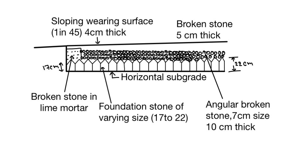
3. Telford Construction
His work started in the early 19th century in England. In this also heavy foundation stones were provided above the soil sub-grade and a cross-slope at the top surface was given to ensure the removal of the water.
The main Features of Telford Construction are:
- A level subgrade was prepared of width 9 m.
- The thickness of the foundation stone varied from 17 cm to 22 cm at the center.
- A binding layer of wearing course 4 cm thick was provided with a cross slope of 1 in 45.
- The central portion of about 5.5m width was filled with two layers of angular broken stones to compacted thicknesses of 10 cm and 5 cm.
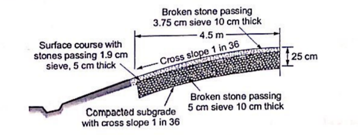
4. Macadam Road
Macadam Road differs from the previous design in the following aspects.
- Soil subgrade was also late at a cross slope 1 in 36 to avoid the seepage of water in it
- He was the first one to suggest that large foundation stones are not required to be placed at the bottom layer.
- Similarly, the next layer of payment is also constructed above this layer with broken stones of smaller size.
- The total thickness of construction was less but load distribution was comparatively better.
- The size Of the broken stone at the top was decided based on stability under animals drawn vehicle.
Development of Roads In India: Mr. Jayakar Committee:
The government of India passed the resolution in 1927 for the appointment of a committee to examine the situation and development of roads in India under the leadership of Mr. Jayakar.
Major recommendations of the Jayakar committee are as follow:
1. The road development in the country should be the subject of national interest (Result: Fund contribution for road development).
2. An extra tax should be charged on Petrol and dissel from the user for the development and maintenance of the road. (Result: Centre Road Fund establish in 1929- first outcome of Jay committee)
3. A semi-official technical body should be formed to give technical knowledge for development of road. (Result: {IRC} India Road Congress establish in 1934- first outcome of Jay committee)
- A research organisation should be instituted to carryout research and developed new techniques of ROAD DEVELOPMENT.
- As per recommendation of Jayakar Committee CENTRAL ROAD FUND (CRF) was established in 1929.
- At the approval of government and semi-official technique body was established in 1934 termed as IRC ( India Road Congress).
- In 1939 Motor Vehicle Act was brought in place to frame the law and ordinate relatively to traffic [it governs driver, vehicle, and operation].
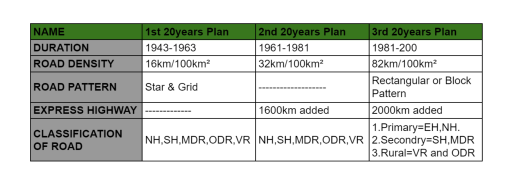
- A conference of chief engineers of all states was called by JRC for collective development of roads in India in 1943 (1st 20-year plan 1943-1963, but it was completed in 1961 only termed as “Nagpur Road Plane“.
- In the Nagpur Road plan target of 60 km / 100km² of the country for the development of the road wants to be achieved.
- In 1950 Central Road Research Institute (CRRI) was established to carry out research of rode technology.
- In 1956 National Highway Act (NHAI) was passed for following Purpose.
- To declare certain selected Highway as national highway.
- To enter into any land to carry out a surveys.
- To acquire land and take possession for the development of a highway.
- Due to earlier completing first 20 year plan in 1961 second 20 year plan was in initiated in 1961 to 1981 for a Bombay termed as “Bombay Road Plane“.
- In the Bombay Road Plan developments 32 km of road length per 100km² of area.
- In 1973, HRB {Highway Research Board} & India Road Congress {IRC} were set up to give direction and guidelines for research activity in India.
- In 1981 third of the 20-year-old development plan was introduced. (1981 to 2001) and Lucknow 80 km of road length / 100 km² of area.
- In 1988 NHAI Act was passed.
- In 2000 PMGSY was launched by the Indian government to increase the connectivity of the village.
- Fourth 20 years Road development plan should have been introduced in 2001 but an the instance of a government JRC preferred rod development plan vision 2021 and 2025.
Comparison Between Various Road Development Plans
Note: Length of Road as per 3rd 20 Years Road Plan:
1.Total length of road = {4.74 × No of towns and villages} or {Road density ×Area}, whichever is maximum.
2. National Highway and State Highway
- Length of NH in km= { Area (km²)÷50}.
- Length of SH in km= { Area (km²)÷25} or {62.5× no of towns in state – Length of NH}, whichever is maximum.
3. Length of Major District Road (km)
- { Area (km²)÷12.5} or {90× no of towns in state},whichever is maximum.
Classification of Road:
Roads are classified as follows:
1. Based on the duration of their use
All Weather Road
- Paved and Non-Paved Roads.
Fair Weather Road
- Surface and Non-Surface Roads.
2. Based on traffic volume
Light Traffic Roads
- The roads which carry 400 vehicles daily on average are called light traffic roads.
Medium Traffic Roads
- If a road is carrying 400 to 1000 vehicles per day, then it is said to be a medium-traffic road.
High Traffic Roads
- If a road is carrying is more than 1000 vehicles per day then it is considered a high-traffic road.
3. Based on location and function
National Highways (NH)
- National Highways are main highways running through the length and breadth of India, connecting major ports, foreign highways, capitals of large states, and large industrial and tourist centers including roads required for strategic movements for the defense of India.
State Highways (SH)
- State Highways are arterial roads of a state, connecting up with the national highways of adjacent state, district headquarters and important cities within the state and serving as the main arteries for traffic to and from district roads.
Major District Roads (MDR)
- MDR are important roads with a district serving area of production, and materials and connecting with other major roads and state highways.
Other District Roads (ODR)
- ODR roads serve rural areas of production and provide then an outlet to the market.
Village Road (VR)
- VR is the road connecting the village or village of groups with each and ODR.
Note: Urban roads are also classified as follows
- Arterial Road
- Sub Arterial Road
- Collector Streets
- Local Streets
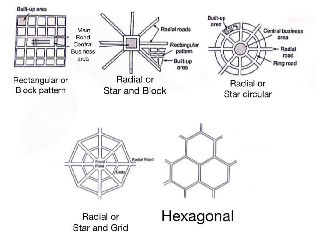
Types of Road Patterns
The various types of road patterns may be classified as follows:
- Rectangular or Block Pattern
- Hexagonal
- Radial or Star and Block
- Radial or Star and Circular
- Radial or Star and Grid
Engineering Surveys For Highway Alignment:
In order to decide or finalized the Probable Alignment following Surveys are being carried out:
- Map Study.
- Reconnaissance.
- Preliminary Survey.
- Detailed or Final survey.
MAP Study
In map study various alignment are drown on map Passing through minimum no of obstructions. and may utilization area.
Reconnaissance
It is done by visiting the location under consideration to identify the features which are not available on map of which are changed over the Period of the time. Feasibility is also checked for all the Possible alignment. in this stage.
Preliminary Survey
In this Survey chain, compass, leveling work, Soil investigation, drainage Provision, traffic Studies are carried out and road alignment is finalized.
Detailed Survey
In this planning designing martial estimation and cost estimation etc are done and a detailed project report (DPR) is prepared.
Maximum Saturation System / Utility Factor System
This system is used to choose the best alignment among various option available.
It depends upon “Population and Production“.
Rules to Decide The factor
- Provide utility factor of 0.5 to the lowest population range and increased it by multiplying with ‘2’ for nest range of population. Ex-0.5,1,2,4,8,and so on….
- Provide utility factor 1 for agriculture.
- Provide utility factor to the industrial production as per the weightage.
Example:
There are 4 alternate proposal of a road plan for backward district. The details are given as follows justify with reason which proposal is the best .Assuming utility units of 0.5,1,2,4,8…. for the 5 population range and 1 and 5 per thousand tonnes agricultural and industrial products served.
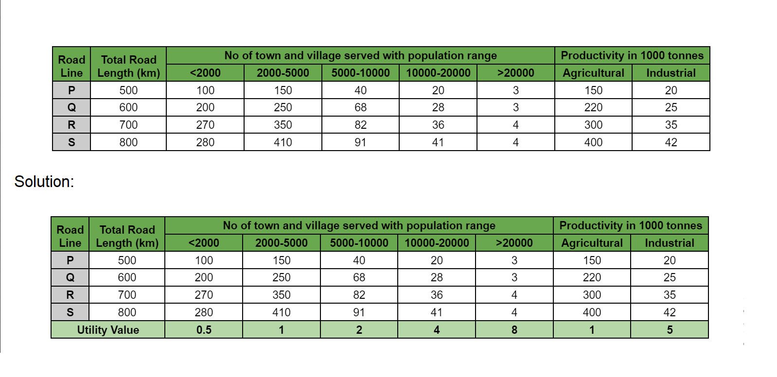
Total Utility Value Per Unit Length:
For P= \(\frac{100×0.5+150×1+40×2+20×4+3×8+150×1+20×5}{500}\)=1.268.
For Q= \(\frac{200×0.5+250×1+68×2+28×4+3×8+220×1+25×5}{600}\)=1.611.
For R= \(\frac{270×0.5+350×1+82×2+36×4+4×8+300×1+35×5}{700}\)=1.857.
For S= \(\frac{280×0.5+410×1+91×2+41×4+4×8+400×1+42×5}{800}\)=1.922.
The preference of the proposal is S>R>Q>P.